
So who is correct? When was Jericho destroyed? Was it in the Late Bronze Age around 1406 BC, as the Bible suggests (based on 1 Kings 6:1, Judges 11:26-27, Acts 13:19-20 and the number of generations listed 1 Chron. 6:33-38)6 or was it destroyed at the end of the Middle Bronze Age around 1550 BC? To answer this, let’s look at three of the ways scholars have attempted to date the destruction layer at Jericho.
Carbon-14
Carbon-14 dating measures the decay of radiocarbon isotopes in organic matter. Assuming the ratio of C-14 in the past was the same as today, scientists measure the proportion of remaining carbon-14 in a sample to determine the amount of time elapsed since the death of the source. Results are given in a number of years BP (Before Present), and then converted into calendar years.7 Carbon-14 is normally accurate to within 15 years, but the older the sample, the more necessary it is to calibrate and corroborate dates using other means.8 Indeed, there is a current debate in the field of archaeology concerning how accurate Carbon-14 dating is in the Levant9, as well as whether there is a need to recalibrate the curve used in radiocarbon calculations.10
Over the years several samples of charcoal and grain seeds from the final Canaanite city at Jericho have been tested for C-14 levels. The current Italian-Palestinian excavation team, directed by Lorenzo Nigro, tested two samples from the final destruction of the city in 2000; one sample dated to 1347 BC (+/- 85 years) and the other dated to 1597 (+/- 91 years).11 Archaeologist, Dr. Titus Kennedy, has summarized: “The first of these dates fits roughly around the proposed 1400 BC destruction, while the other is closer to the proposed 1550 BC destruction…these dates are so broad that they are useless in contributing to solving the problem for the date of destruction. Overall, the C-14 dates from the destruction of the Bronze Age city of Jericho range from as high as 1883 BC to as low as 1262 BC—a range of over 600 years.”12 Clearly we will need to look to other methods to determine when Jericho was destroyed.
Glyphs and Inscriptions
Artifacts with glyphs (carved symbols) and inscriptions (written texts) are very helpful in establishing the date that a site was occupied. Both the style of the object in question (typology) and the style of writing on it (epigraphy) are used by scholars to determine when the artifact was made. Inscriptions are found often found on monuments, clay tablets, scarabs, etc.
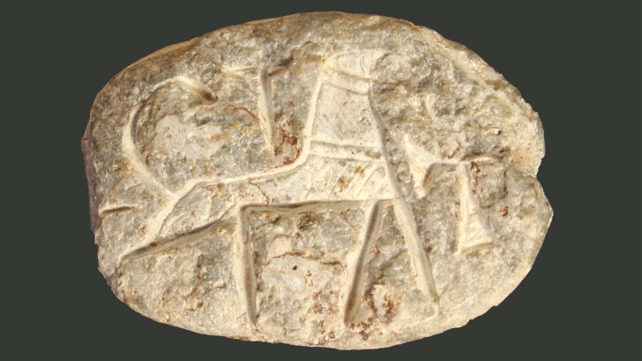
Scarabs are Egyptian amulets in the shape of a dung beetle that often include an inscription on the bottom. Because they were widely collected and distributed in antiquity they are frequently found in digs throughout Israel. Sometimes scarabs include the name of a particular pharaoh, which makes them helpful in archaeological dating.
When Garstang excavated Jericho in the 1930’s he discovered several Egyptian scarabs in tombs to the northwest of the city. The scarabs bore inscriptions with the royal names of three Pharaohs:
- Hatshepsut (ca. 1503-1483 BC)
- Thutmose III (ca 1504-1450 BC)
- Amenhotep III (ca. 1386 BC-1349 BC)13
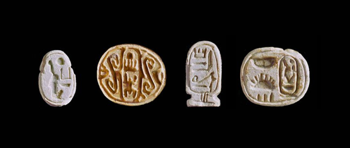
Pharaohs like Thutmose III and Amenhotep III were popular and revered long after they died. Consequently, their scarabs were copied and collected for many years. Hatshepsut, however, was despised and her name was systematically erased from inscriptions in Egypt in antiquity. Her scarabs are rare because they were not copied or kept as good-luck charms. The rarity of Hatshepsut scarabs makes them excellent chronological indicators.14 In addition to these, Kenyon herself discovered an inscribed cowrie (snail shell), which has been dated to 1485 BC.15 Taken together, the continuous nature of the dates of these scarabs and cowrie demonstrate that the cemetery outside Jericho was actively used through to the end of the 15th century BC.16 This contradicts Kenyon’s claim that the city had been abandoned after it was supposedly destroyed in 1550 BC.
The current lead excavator, Lorenzo Nigro, while espousing Kenyon’s dating, acknowledges that the site was occupied during the Late Bronze Age. He notes, “On the eastern flank of the tell, Garstang retrieved a LB clay tablet preserving an administrative text, which suggests that the city still had a political role, a palace, a ruler, and even an archive.”17
The glyphic and inscriptional evidence demonstrates that Kenyon’s interpretation that Jericho was abandoned at the time of the Conquest of Canaan in 1406 BC is incorrect.
Ceramic Typology
Ceramic Typology is the classification of pottery based on its physical characteristics. Archaeologist, such as Petrie, Albright, and Glueck demonstrated that the different styles of pottery could be used to date the strata in which they were discovered. Today, ceramic typology is one of the most important and accurate means of dating in archaeology.17 Many excavations end each day with “pottery reading” to determine the date of the pottery based on the rims, handles, grit and markings of the sherds that were unearthed.
Archaeologist, Dr. Bryant Wood, an expert in Canaanite pottery, conducted a comprehensive study of the excavation reports of Garstang and the various writings of Kenyon (she never produced an excavation report on Jericho before she died, although one was published posthumously). Wood discovered that Kenyon had based her dating of the destruction of Jericho solely on the absence of imported pottery. During her excavations at Jericho, Kenyon did not find any imported bichrome (two-color) pottery from Cyprus, which is a prime indicator of Late Bronze I occupation. Thus, she concluded that it was unoccupied at his time and had been destroyed 150 years earlier.18 (She would have done well to follow esteemed Egyptologist, Kenneth Kitchen’s maxim, “The absence of evidence is not evidence of absence.”)
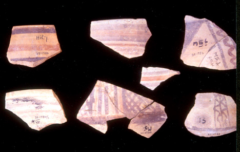
Inexplicably, Kenyon seems to have failed to consider the pottery discovered by Garstang. He had unearthed numerous examples of a locally made, imitation bichrome “Cypriot” pottery from the destruction layer of the final Canaanite city of Jericho. Garstang called it “red ware” and several of the pieces he published have classic Cypriot bichrome motifs.19 Locally made imitation bichrome pottery came into use in the Late Bronze IB period and was no longer made in the Late Bronze IIA.20 Since both Garstang and Kenyon were digging in the poorer sections of Jericho, it’s hardly surprising that only locally made bichrome pottery was found, and that the real, fancy, Cypriot bichrome pottery was absent. The local pottery that Garstang and Kenyon found indicates that Jericho was destroyed around 1400 BC.
Summary
Both Garstang and Kenyon conducted significant excavations at Jericho. Both were excellent field archaeologists Garstang meticulously analyzed the pottery he excavated and Kenyon carefully improved excavation methodology in general. Yet both differed on their interpretation of the data. While the Carbon-14 data is of no help in determining the date of the destruction of Jericho, the dating of from glyphic/inscriptional evidence and ceramic typology would indicate that Garstang’s original date of ca. 1400 BC is the correct date. This would support the biblical chronology of Joshua’s army destroying Jericho in what we now call the Late Bronze Age I.
Title Photo: Fullo88 / Wikimedia Commons / Public Domain
Endnotes:
1 William G. Dever, Recent Archaeological Discoveries and Biblical Research (Seattle: University of Washington Press, 1990), 46.
2 Bryant Wood, “Did the Israelites Conquer Jericho? A New Look at the Archaeological Evidence,” BAR 16:2 (1990): 44-58, 53. Online: https://biblearchaeology.org/research/conquest-of-canaan/2310-did-the-israelites-conquer-jericho-a-new-look-at-the-archaeological-evidence?highlight=WyJjeXByaW90Il0= (Accessed May 9, 2019).
3 John Garstang, “Jericho and the Biblical Story,” in Wonders of the Past, ed. J.A. Hammerton (New York: Wise, 1937), 1222.
4 Kathleen Kenyon, Digging Up Jericho (London: Ernest Benn, 1957), 262.
5 Bryant Wood, “Did the Israelites Conquer Jericho? A New Look at the Archaeological Evidence,” BAR 16:2 (1990): 44-58, 53. Online: https://biblearchaeology.org/research/conquest-of-canaan/2310-did-the-israelites-conquer-jericho-a-new-look-at-the-archaeological-evidence?highlight=WyJjeXByaW90Il0= (Accessed May 9, 2019).
6 A good summary of the verses that point to an early date for the Exodus (and by implication the conquest 40 years later) in the 15th century B.C. can be found in the following episodes of Digging for Truth: https://www.youtube.com/watch?v=bxXXTGD_y40&t=1312s and https://www.youtube.com/watch?v=8-mUoS5RvBU&t=1379s In addition, these episodes of Digging for Truth highlight the archaeological evidence for an early Exodus/Conquest: https://www.youtube.com/watch?v=iPYkoKyRfKw&t=1s and https://www.youtube.com/watch?v=XpRUe6-tkzQ&t=20s
7 “Radiocarbon Dating and Archaeology,” Beta Analytic Testing Laboratory, https://www.radiocarbon.com/archaeology.htm (Accessed May 10, 2019).
8 Scott Stripling, The Trowel and the Truth (Ramona: Vision Publishing, 2017), 53.
9 Sturt W. Manning, Carol Griggs, Brita Lorentzen, Christopher Bronk Ramsey, David Chivall, A. J. Timothy Jull, and Todd E. Lange, “Fluctuating radiocarbon offsets observed in the southern Levant and implications for archaeological chronology debates,” PNAS June 12, 2018 115 (24) 6141-6146; first published May 29, 2018 https://doi.org/10.1073/pnas.1719420115 (Accessed May 11, 2019).
10 Daniel Aloi, “New radiocarbon cycle research may alter history” Cornell Chronicle, June 1, 2018. http://news.cornell.edu/stories/2018/06/new-radiocarbon-cycle-research-may-alter-history (Accessed May 11, 2019)
11 Bryant Wood, “Carbon 14 Dating at Jericho” Associates for Biblical Research, August 7, 2008. https://biblearchaeology.org/research/conquest-of-canaan/4051-carbon-14-dating-at-jericho (Accessed May 11, 2019).
12 Titus Kennedy, “Carbon-14 Dates at Jericho and the Destruction Date” APXAIOC, October 22, 2012. http://www.apxaioc.com/article/carbon-14-dates-jericho-and-destruction-date (Accessed, May 11, 2019).
13 Bryant Wood, “Did the Israelites Conquer Jericho? A New Look at the Archaeological Evidence,” BAR 16:2 (1990): 44-58, 53. Online: https://biblearchaeology.org/research/conquest-of-canaan/2310-did-the-israelites-conquer-jericho-a-new-look-at-the-archaeological-evidence?highlight=WyJjeXByaW90Il0= (Accessed May 9, 2019).
14 Ibid.
15 Bryant Wood, “Digging Past The Doubts,” Answers In Genesis. October 1, 2015. https://answersingenesis.org/archaeology/digging-past-doubts/ (Accessed May 13, 2019).
16 Bryant Wood, “Dating Jericho’s Destruction: Bienkowski is Wrong on All Counts,” Associates for Biblical Research, March 28, 2012. https://biblearchaeology.org/research/conquest-of-canaan/2945-dating-jerichos-destruction-bienkowski-is-wrong-on-all-counts?highlight=WyJzY2FyYWJzIiwiJ3NjYXJhYnMiXQ== (Accessed May 11, 2019).
16 Lorenzo Nigro, “TELL ES-SULTAN 2015 A Pilot Project for Archaeology in Palestine,” Near Easter Archaeology 79:1 (2016), 16. Online: http://www.lasapienzatojericho.it/Biblioteca/Jericho/TELL_ES-SULTAN_Jericho_2015_A_Pilot_Proj.pdf (Accessed May 13, 2019).
17 Scott Stripling, The Trowel and the Truth (Ramona: Vision Publishing, 2017), 52.
18 Bryant Wood, “Did the Israelites Conquer Jericho? A New Look at the Archaeological Evidence,” BAR 16:2 (1990): 44-58, 53. Online: https://biblearchaeology.org/research/conquest-of-canaan/2310-did-the-israelites-conquer-jericho-a-new-look-at-the-archaeological-evidence?highlight=WyJjeXByaW90Il0= (Accessed May 9, 2019).
19 Bryant Wood, “Dating Jericho’s Destruction: Bienkowski is Wrong on All Counts,” Associates for Biblical Research, March 28, 2012. https://biblearchaeology.org/research/conquest-of-canaan/2945-dating-jerichos-destruction-bienkowski-is-wrong-on-all-counts?highlight=WyJzY2FyYWJzIiwiJ3NjYXJhYnMiXQ== (Accessed May 11, 2019).
20 Bryant Wood, Personal email to the author. May 10, 2019.
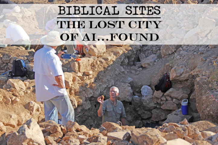
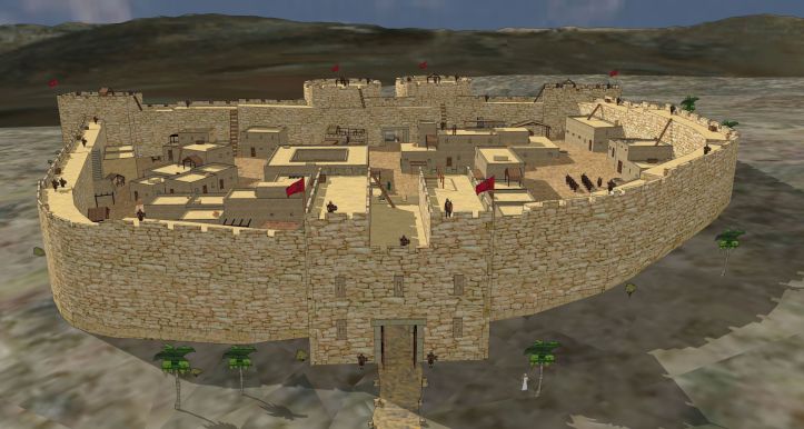
Joshua 7 and 8 recount the First and Second Battles of Ai. Et Tell has been accepted as the default site of Ai since W.F. Albright’s article on the subject in 1924.1 Et-Tell, however, fails to meet the biblical criteria for the city. Joseph Callaway, who excavated at et-Tell from 1964 –70 concluded: “Ai is simply an embarrassment to every view of the conquest that takes the biblical and archaeological evidence seriously.”2But what if they were looking at the wrong site? What if et-Tell is not the city of Ai that Joshua and the Israelites conquered? BRYAN WINDLE
When Edwin Robinson explored the area in 1838, the local people pointed to a different site – Khirbet el-Maqatir – as Ai.3 Between 1995 and 2017 the Associates for Biblical Research (BibleArchaeology.org) excavated at Khirbet el-Maqatir and meticulously uncovered a fortified settlement from the time of Joshua that had been destroyed by fire. Archaeologist Gary Byers, who served as the administrative director of ABR’s excavations at Khirbet el-Maqatir says there are three ways we can know that this is the site of Joshua’s Ai: it has the right stuff in the right place at the right time.4
Right Place
In order to identify the site of the ancient city of Ai from Joshua’s day a number of biblical criteria need to be met relating to geography and topography:
It must:
- Be adjacent to Beth Aven (Josh. 7:2)
- Be East of and near to Bethel (Josh. 7:2; 12:9)
- Have an ambush site between Bethel and Ai (Josh. 8:9, 12)
- Have a militarily significant hill north of Ai where the Israealite army camped (Josh. 8:11)
- Be close to a shallow valley north where Joshua and the decoy force could be seen by the king of Ai (Josh. 8:13–14);
The late Dr. David Livingston identified Bethel as modern el-Bireh. Building on his work, archaeologist Dr. Bryant Wood convincingly argued Bethel is indeed modern el-Bireh and Beth-Aven is modern Beitin and that only Khirbet el-Maqatir satisfies all of the above criteria.5 Geographically, it lies due east of Bethel/el-Bireh and only 1 mile southeast of Beth Aven/Beitin.
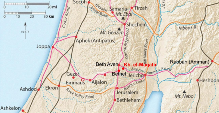
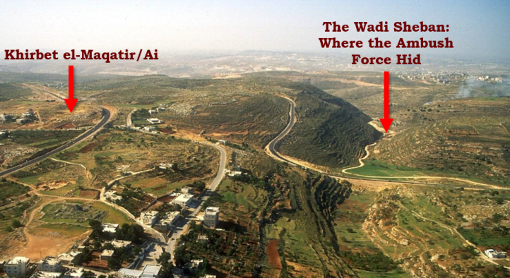
Today, one can see how the battle unfolded by looking at the topography around Khirbet el-Maqatir. North of the site is the highest hill in the region, called Jebel Abu Ammar, where Joshua’s main force encamped. Between it and Khirbet el-Maqatir is a shallow valley where the King of Ai could see the Israelite decoy force coming to battle. Immediately west of the site is the steep valley of the Wadi Sheban in which Joshua’s ambush force hid.
Right Stuff
In addition to being the in the right place, the site of Ai must also have the right stuff. Specifically, it must:
- Have fortification walls (it is called a “fortified place” in Josh. 8:1-2)
- Have a main gate facing north (implied in Josh 8:11)
- Be a relatively small site (Josh. 7:3; 10:2)
- Have evidence of the presence of women. (Josh. 8:25)
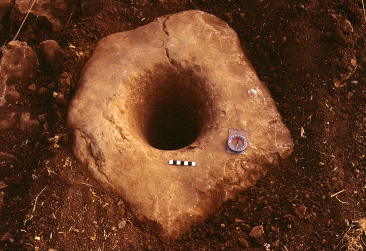
Excavations at Khirbet el-Maqatir have revealed a small border fortress dating to the Middle and Late Bronze Ages. Although only about 2.5 acres in size the foundation of the fortification walls on the north and west side were found to be 13 feet wide. On the north side of the fortress, a four-chambered gate was unearthed. Two of the gate’s socket stones were discovered in the gate passageway and others were found nearby.6
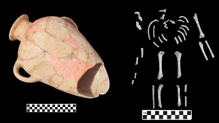
The Bible describes the presence of women at Ai in Joshua 8:25, which would initially seem a strange thing at a border military fortress. However, archaeological evidence of this came in 2009 when an infant burial jar was discovered at Khirbet el-Maqatir with the child’s remains scattered around the jar. The typology of the offering vessels and the burial jar itself suggest that the infant was buried sometime around 1500 B.C.
Interestingly, there are the remains of a Byzantine monastery at Khirbet el-Maqatir. The Byzantines often built their churches upon biblical sites and may have built the one here to commemorate the Israelite victory over Ai.
Right Time
The biblical date for the conquest and the Battles of Ai would be 1406 B.C. (near the end of the Late Bronze Age I period). This is deduced from a straightforward reading of a number of passages dating the Exodus to 1446 B.C.: 1 Kings 6:1, Judges 11:26-27, Acts 13:19-20 and the number of generations listed 1 Chron. 6:33-38.7Therefore, any candidate site for the biblical city of Ai that Joshua’s army defeated must meet the following criteria:
- Evidence of occupation during the 15th century B.C.
- Evidence of destruction by fire in the 15th century B.C. (Josh. 8:19; 8:28)
Excavations at Khirbet el-Maqatir revealed ample pottery dating to the Late Bronze Age I, much of which had been refired in a site-wide conflagration. This is consistent with a site that had been destroyed by fire as described in Joshua 18:28: “So Joshua burned Ai and made it forever a heap of ruins, as it is to this day.”8
Three Egyptian scarabs were found at the site, including two from the period of the fortress: one dating to the the Middle Bronze III period (ca. 1650–1485 B.C.) and another rarer scarab dating to the 18th Dynasty, likely in the reign of Amenhotep II (ca. 1455-1418 B.C.). This second scarab was discovered in situ in a sealed locus, providing a terminal date for the fortress toward the end of the 15th century B.C. Archaeologist, Dr. Scott Stripling concludes: “The two scarabs synchronize with the ceramic analysis and provide firm dates for the operation of the fortress. It now seems clear that the small fortress, likely the Ai of Joshua 7-8, was constructed during the MB III boom and was violently destroyed near the end of LB I.”9
SUMMARY:
In the absence of any ancient inscription identifying a site, scholars are left to match the archaeological remains with what is known about a place from history. In the case of Ai, the only ancient text with information about the site is the Bible and Khirbet el-Maqatir is the only site that meets all of the biblical criteria. It has the right stuff in the right place at the right time. Rather than being an “embarrassment,” correctly identifying Khirbet el-Maqatir as the site of the city of Ai that Joshua defeated demonstrates the historical reliability of the biblical account of the conquest in the 15th century B.C.
ENDNOTES:
1 William F. Albright, “Ai and Beth Aven.” Pp. 141–49 in Excavations and Results at Tell el-Ful (Gibeah of Saul). The Annual of the Americal Schools of Oriental Research 2, ed. Benjamin W. Bacon. New Haven CT: American Schools of Oriental Research, 1924.
2 Bryant G. Wood, “The Search for Joshua’s Ai.” In Critical Issues in Early Israelite History, edited by Richard S. Hess, Gerald A. Klingbeil, and Paul J. Ray Jr, 205. Winona Lake: Eisenbrauns 2008. http://www.biblearchaeology.org/file.axd?file=The+Search+for+Joshuas+Ai.pdf (Accessed March 28, 2019).
3 Todd Bolen, “Khirbet el-Maqatir.” Bible Places. https://www.bibleplaces.com/maqatir/ (Accessed March 28, 2019).
4 Gary Byers in a personal email to the author. March 5, 2019
5 Bryant G. Wood, “The Search for Joshua’s Ai.” In Critical Issues in Early Israelite History, edited by Richard S. Hess, Gerald A. Klingbeil, and Paul J. Ray Jr, 210-240. Winona Lake: Eisenbrauns 2008. http://www.biblearchaeology.org/file.axd?file=The+Search+for+Joshuas+Ai.pdf (Accessed March 28, 2019).
6 Bryant G. Wood, “Excavations at Khirbet el-Maqatir: 1995 to 2000 and 2009 to 2011.” Associates for Biblical Research. April 4, 2012. http://www.biblearchaeology.org/post/2012/04/04/Excavations-at-Khirbet-el-Maqatir-1995-to-2000-and-2009-to-2011.aspx (Accessed April 2, 2019).
7 A good summary of the verses that point to an early date for the Exodus (and by implication the conquest 40 years later) in the 15th century B.C. can be found in the following episodes of Digging for Truth: https://www.youtube.com/watch?v=bxXXTGD_y40&t=1312s and https://www.youtube.com/watch?v=8-mUoS5RvBU&t=1379s In addition, these episodes of Digging for Truth highlight the archaeological evidence for an early Exodus/Conquest: https://www.youtube.com/watch?v=iPYkoKyRfKw&t=1s and https://www.youtube.com/watch?v=XpRUe6-tkzQ&t=20s
8 Scott Stripling, “2014 Excavations at Kh. el-Maqatir: A Proposed New Location for Ai and Ephraim.” Associates for Biblical Research. March 9, 2015. http://www.biblearchaeology.org/post/2015/03/09/2014-Excavations-at-Kh-el-Maqatir-A-Proposed-New-Location-for-Ai-and-Ephraim.aspx (Accessed March 2, 2019).
9 Ibid.

It was said of old that the borders of ancient Israel were “from Dan to Beersheba.” (Judges 20:1; 1 Sam. 3:20; 2 Sam. 17:11; 1 Kings 4:25; 1 Chron. 21:2; 2 Chron 30:5). The city of Dan, on the northernmost border of Israel, was originally named Leshfem before the Danites captured it, renaming it Dan, after their ancestor (Joshua 19:47). Mentioned 20 times in Scripture, Dan came to be associated with idolatry as one of the two places Jeroboam I set up a golden calf for the northern Kingdom of Israel to worship (1 Kings 12:28-29). BRYAN WINDLE
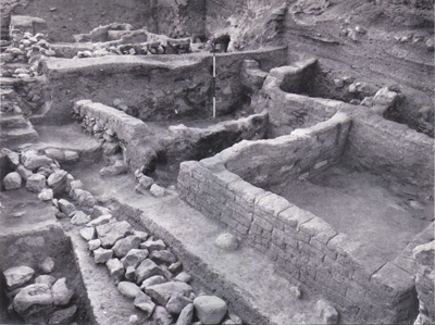
Tell el-Qadi was positively identified as the site of ancient Dan when a Hellenistic-era inscription in Greek and Aramaic was discovered which records a vow that a person named Zoilos made “to the god who is in Dan.”1 Excavations at Tell el-Qadi/Tell Dan began in 1966 under the direction of renowned Israeli archaeologist Avraham Biran, who dug there for 30 years. In 2005, archaeologists from the Nelson Glueck School of Biblical Archaeology of Hebrew Union College-Jewish Institute of Religion renewed excavations at Tell Dan. Over the years a number of spectacular discoveries have been made at Tell Dan which affirm historical details about the site found in the Bible.
City Gates
Two significant city gates have been discovered at Tell Dan: one from the Canaanite city and one from the Israelite city.
In the 18th century BC, the Canaanites at Lesham (Dan) built an imposing mudbrick gate. This massive entrance to the city featured a triple-arched entrance with two towers – one on each side. It has sometimes been dubbed, “Abraham’s Gate” because Abram once rescued his nephew lot from his kidnappers near Dan (Gen. 14:14). However, this mudbrick gate was only built ca. 1750, while Abraham lived from ca. 2166 to 1991 BC2. He may have seen an earlier version of this gate, but the actual structure that survives today was built over 200 years after he died. The 3700+ year-old mudbrick gate survives today at a height of 7 meters and it is the earliest intact archway in the world.3
Equally as impressive is the gate complex from the Israelite city. The remains of the Iron Age gate, likely built in the time of King Ahab,4 have been partially restored. The gate’s chambers may have served as guard stations, storage rooms or a place for merchants to sell goods.5 Archaeologist, Avraham Biran, discovered a raised platform inside the main gate, with decorated socket stones that may have supported a canopy. Different suggestions have been proposed for its function: It may have been a place for the king or judge to sit to oversee the city business (2 Samuel 18:4) or it may have been a shrine where an idol was displayed (2 Kings 23:8).6

Altar/High Place
When the Hebrew Kingdom split in the 10th century BC, Jeroboam was made king of Israel and reigned in Shechem (1 Kings 12:25). One of his first acts was to establish a place of worship for the Northern Kingdom so that the people of Israel would not return to Jerusalem to offer sacrifices. He set up two golden bull calfs – one on the southern border in Bethel, and one on the northern border at Dan – and called them Elohim, declaring that these gods had brought the people out of Egypt. (1 Kings 12:26-29).
On the north side of Tell Dan, the remains of the High Place, the Israelite Temple, were found. Numerous cultic artifacts were unearthed, including iron shovels, an incense holder and a small horned altar. In addition, a large raised platform was excavated, which was in use during the time of King Jeroboam, was rebuilt in the days of Joash (8th century BC) and reused again from the Hellenistic era until the end of the Roman Period.7 Most archaeologists agree that this platform was the one on which Jeroboam’s golden calf once stood.8

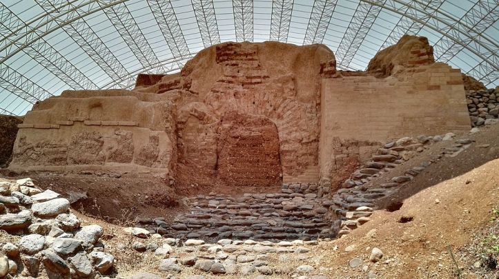
Tell Dan Stele
In 1993 archaeologists were excavating part of a wall, when they discovered a broken stone, approximately 32 cm high by 22 cm wide, with an Aramaic inscription on it. The next year, two more fragments of the stele were unearthed. It turned out to be a victory stele that the king of Aram had erected when he captured Dan sometime in the 9th century BC. When the Israelites regained control of Dan, they tore down the monument and broke it up, using the pieces in the construction of a new city gate.
The stele records the victory of a King of Aram – most likely Hazael, although he is not named – over the King of Israel, and his ally, the king of the “House of David.”9 It was the phrase, “House of David” that set the archaeological world afire. Given the stele’s date (ca. 841 B.C. – about 200 years after David’s rule) and its historical context (that the kings of Israel and Judah were allies at this time, on guard against Hazael the king of Aram – 2 Kings 9:14-16), the majority of scholars and archaeologists have concluded that the Tell Dan Inscription does indeed reference King David. Archaeologist, Yosef Garfinkel explains the importance of the “House of David” inscription: “‘House of David’ means ‘dynasty of David’. So now we know that there was a guy called David and he had a dynasty…[it] is absolutely clear that David is not a mythological figure. So the mythological paradigm collapsed in one moment.”10

Summary
Important archaeological discoveries at Tell Den shed light on the Israelite Kingdom, especially during the 10th and 9th centuries BC. They attest to the fact that the ancient city of Dan was an important center in Israel’s history and affirm biblical details from the site.
Title Photo: Mboesch / Wikimedia Commons / CC BY-SA 4.0
Endnotes:
1 “Archaeological Sites in Israel-Dan- The Biblical City” Israel Ministry of Foreign Affairs. July 29, 1998. https://mfa.gov.il/mfa/israelexperience/history/pages/archaeological%20sites%20in%20israel%20-%20dan-%20the%20biblical.aspx (Accessed May 29, 2019).
2 Andrew E. Steinmann, From Abraham To Paul: A Biblical Chronology. (St. Louis: Concordia Publishing House, 2011), 72.
3 “Mudbrick Gate,” Tel Dan Excavations. https://teldan.wordpress.com/mudbrick-gate/ (Accessed May 29, 2019).
4 Bryant G. Wood, “Ahab the Israelite.” Associates for Biblical Research. Jan. 2, 2006. https://biblearchaeology.org/research/divided-kingdom/3584-ahab-the-israelite?highlight=WyJhaGFiIiwiYWhhYidzIiwiJ2FoYWIiLCJ0aGUiLCIndGhlIiwidGhlJ3lhaHdlaCIsInRoZSdzY2hvbGFycyciLCJ0aGUnZmllcnkiLCJ0aGUna2luZyIsInRoZScwJyIsInRoZSd3YXRlcnMiLCJpc3JhZWxpdGUiLCJpc3JhZWxpdGUncyIsIidpc3JhZWxpdGUnIiwiYWhhYiB0aGUiLCJhaGFiIHRoZSBpc3JhZWxpdGUiLCJ0aGUgaXNyYWVsaXRlIl0= (Accessed May 29, 2019).
5 “Discoveries,” Tel Dan Excavations. https://teldan.wordpress.com/discoveries/ (Accessed May 29, 2019).
6 Todd Bolen, “Dan.” Bible Places. https://www.bibleplaces.com/dan/ (Accessed May 29, 2019).
7 “Tell Dan,” Bible Walks. Oct. 1, 2010. https://biblewalks.com/sites/TellDan.html (Accessed May 30, 2019).
8 Todd Bolen, “Dan.” Bible Places. https://www.bibleplaces.com/dan/ (Accessed May 30, 2019).
9 Biblical Archaeology Society Staff, “The Tel Dan Inscription: The First Historical Evidence of King David from the Bible,” Biblical Archaeology Society. May 2, 2019. https://www.biblicalarchaeology.org/daily/biblical-artifacts/the-tel-dan-inscription-the-first-historical-evidence-of-the-king-david-bible-story/ (Accessed May 30, 2019).
10 “King David & Archaeology, Part 1: The Valley of Elah” CBN Documentaries. https://www.youtube.com/watch?v=vqptqx-JAAA (Accessed May 29, 2019).

Everyone loves a good mystery! In the world of biblical archaeology there are many mysteries to solve. One in particular is the question of where the town of Bethsaida is located. Lost to history centuries ago, two sites are currently the leading candidates as the true location of this biblical town. In this two-part series, we’ll explore the evidence for et-Tell and el-Araj, to determine which site is the likely location. SEPTEMBER 5, 2019BRYAN WINDLE
Criteria For Bethsaida
Before beginning, it is important to examine the descriptions in the Gospels and other ancient writings to determine what we should look for.
Geography: Located on the northeast shore of the Sea of Galilee
- In Mark 6:45, we read, “Immediately he [Jesus] made his disciples get into the boat and go before him to the other side, to Bethsaida…” implying that the village was on the shore of the Sea of Galilee.
- When Jesus pronounced his woes on the villages that had not responded to his message, he specifically centered out – Chorazin, Bethsaida, and Capernaum – which would indicate these three were relatively close to each other. (Matt. 11:21-24). Thus, Bethsaida should be found on the northern end of the Sea of Galilee.
- After the feeding of the five thousand, which Luke locates near Bethsaida, the disciples got into a boat and “started across the sea to Capernaum.” (John 6:17). Since Capernaum is on the northwest shore of the Sea of Galilee, this would place Bethsaida on the northeast shore of the Sea of Galilee.

Topography: Located near a desolate hill or mountain
- According to Luke 9:10-17, the Feeding of the five thousand took place near Bethsaida. Mathew and Mark’s gospels state that this event occurred in a “desolate place” (Matt. 14:13 & Mark 6:35), while John records that it occurred on a mountain or hill (John 6:3)
- Also, a plain would be located nearby, as Josephus describes in the battles he fought nearby1
Archaeology: Artifacts/Structures related to Fishing, Jewish and Roman Occupation and a Byzantine Church
- Artifacts Related to Fishing – Bethsaida literally means, “house of fish,”2 so we should expect to find artifacts related to the fishing industry.
- Jewish Artifacts from the First Century – Bethsaida is described as a village (kōmē in Mark 8:23). The picture one gets reading the gospels is that Bethsaida was a typical Jewish village, with people coming to hear the rabbi’s teaching and hoping that he would heal them (Mark 8:22)
- Roman Artifacts from the First Century – Josephus records that Herod Philip “provided the village of Bethsaida on lake Gennesaret with the dignity of a city, by increasing the multitude of its inhabitants and by the other honor of naming it Julias, the same name as Caesar’s daughter.”3 Thus we should expect to find some structures of a typical Roman polis in the archaeological record.
- A Byzantine Church –Bethsaida was the home of Philip, Andrew and Peter (John 1:44). In 725 AD, Willabald, Bishop of Bavaria, described coming to Bethsaida and seeing a church that had supposedly been built over the house of Peter and Andrew.4 While the discovery of a Byzantine church is not conclusive proof (it would only indicate that the Byzantines thought it was the location of Bethsaida), it would be one more piece of evidence
The Case for et-Tell

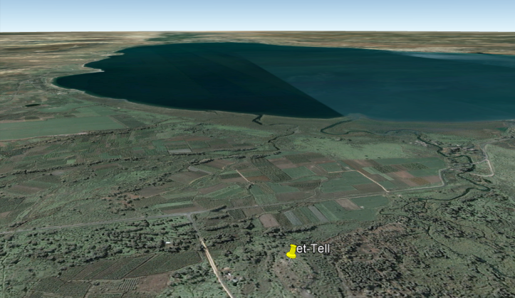
In 1838 Edward Robinson explored the area and identified et-Tell as Julias-Bethsaida. Excavations began there in 1987 under the direction of Dr. Rami Arav and his team. Over the past 30 years, the Bethsaida Excavations Project (BEP), as it is known, has unearthed the remains of a significant Iron Age city. The site also has evidence of occupation during the Hellenistic, Hasmonean, Herodian and Early Roman periods, as well as in the later Mamluk and Ottomon eras.5 It is Arav’s identification of et-Tell as biblical Bethsaida that really put the site on the map.
In his landmark article, “Bethsaida Rediscovered,” in the January/Feburary 2000 issue of Biblical Archaeology Review, Rami Arav laid out his case for identifying et-Tell with Bethsaida. With the recent discoveries at el-Araj, another site that has been identified as Bethsaida, Arav has doubled down on his belief that the true location of the hometown of Peter, Andrew and Philip (John 1:44) is at his site. Let’s analyze these claims in light of the criteria set out above.
Geography
Et-Tell is located 3 km (1.5 miles) from the northern shore of the sea of Galilee. How can a fishing village be so far inland from the water? Arav and his team explain this apparent problem through geology:
“Up against the base of the et-Tell mound, we found lake clays containing crustacean microorganisms. At one time, Bethsaida was right on the water! Further work has refined that finding. At the base of the tell lie terraced deposits of gravel and boulders on top of the lake clays. Carbon 14 dating of bovine bones and other organic matter underneath the boulders has yielded a date between 68 and 375 C.E. We believe that a cataclysmic event, probably the major earthquake of 363 C.E., swept a vast amount of basalt boulders, rock, gravel, soil and artifacts across the plain on which et-Tell lies, cutting Bethsaida off from the shore.”6
Topography
It is difficult to determine what the topography looked like 2000 years ago, especially if the cataclysmic earthquake proposed by the BEP team changed the landscape as much as they’ve proposed. However, there are numerous plains and hills which would hold large numbers of people7, as required by the account of the feeding of the five thousand and the battles Josephus describes.
Archaeology

The BEP excavated a residential quarter at et-Tell, and unearthed two houses from the Hellenistic period that may have been still in use in Jesus’ day. They dubbed one the Winemaker’s House, because it had a wine cellar in which were found four large wine jars. The other house was named the Fisherman’s House, because they discovered lead net weights, anchors, and fishhooks within it.8 In addition, parts of Herodian oil lamps and limestone vessels – the hallmarks of a Jewish village – were discovered at the site.9

The BEP has also uncovered a structure, which they identify as a temple, and believe was repurposed to honor Julia-Livia, wife of Caesar Augustus, after whom the new Roman polis was named.10 Arav describes it this way:
“On the highest part of the mound, atop debris of the Iron Age city gate, there was an old Phoenician temple built in the second century B.C.E. (or perhaps late third century B.C.E.) that was in ruins during the time of Philip…. Philip rebuilt it and converted it into a Roman-style temple by diverting its opening from the north to the east and decorating it with reliefs, dressed stones (the only structure at the site bearing dressed stones), and a marble floor, of which we have found a few remains. The lintel of the temple was decorated with meander and rosettes, recalling the decoration used by his father, Herod the Great, in the Jerusalem temple. These decorations followed the Augustan style and allude to bounty and prosperity, a propaganda hallmark of the pax Romana. Overall, the temple was discovered in a very poor state of preservation. Its dressed stones, floors, and decoration were almost all looted. It is likely that much of it was taken to Chorazin, situated only five miles west of Bethsaida.”11

In addition, several religious objects were found around this structure, including two bronze incense shovels, a bronze ladle, two bronze bowls, a highly decorated oil lamp filler, and several high-quality jugs and juglets.12 The excavators at et-Tell believe these to be evidence of an Imperial cult at the site.
All of this has led Rami Arav to make the bold claim that et-Tell “contains more evidence for its identification with Bethsaida than, for example, Capernaum, Cana, or Chorazin.”13
Problems with et-Tell
Despite the discoveries at et-Tell, and the fact the Israeli government has declared the site to be Bethsaida, not all scholars agree. Todd Bolen from BiblePlaces.com summarizes the difficulties with this identification succinctly:
“There are many problems with the identification of et-Tell with Bethsaida, including:
- Distance from the Sea of Galilee
- Elevation of the site, about 20 feet (7 m) above the level of the lake in ancient times
- Lack of ancient remains from the 1st century A.D., including significant pottery and coins
- Lack of buildings from the New Testament period. After 30 years of digging, excavators have identified only one Roman period house and another building they identify as a Roman temple. This latter identification is dubious.
In short, there is little to commend this site as being the Bethsaida mentioned by Josephus and the Bible.”14
One of the main arguments against et-Tell being Bethsaida is that it is located 3km (1.5 miles) from the shore of the Sea of Galilee. Despite the theory put forth by the excavators at et-Tell to explain the distance, this continues to be a significant stumbling block to their identification. Mendel Nun, an expert on the ancient shoreline of the Sea of Galilee counters the BEP’s explanation of a cataclysmic event separating et-Tell from the shore:
Shroder and Inbar’s theory contradicts the accepted geological explanation of how the shore of the lake was formed. It also contradicts the archaeological evidence. The creation of plains around the lake was, in fact, a result of erosion—mud and rocks were carried by streams through valleys to the lakeshore….The Beteiha Plain was created not by some catastrophic geological event, but by the erosion deposited by the Meshushim, Yehudiyeh and Daliyot Streams, the three streams that flow into the plain.15
As to the BEP’s discovery of lake clays containing crustacean microorganisms, it has been pointed out that, while the plain may have been under water between 2700 and 1800 years ago, this wide 900 year gap does not prove that it was under water in the narrow timeframe of the early first century.16 Furthermore, recent excavations at el-Araj have clearly demonstrated that it was occupied in the New Testament-era. If the Bethsaida plain was under water up to the base of et-Tell, as the BEP excavators claim, then el-Araj would have been submerged. The fact that it was not is significant evidence that the et-Tell was a considerable distance from the shore of the Sea of Galilee even in the first century.
For Steven Notley, a historical geographer and one of the men behind the el-Araj excavations, in addition to the distance from the shore of the Sea of Galilee, another significant issue is one of urbanization; there simply isn’t evidence at et-Tell of a village becoming a Roman polis, as described by Josephus.17 In fact, the archaeological record at et-Tell during the first century seems to exhibit the opposite. Rather than evidence of a larger more Romanized population, et-Tell appears to have become smaller, with fewer Roman artifacts. Using the BEP’s own excavation reports, Notley has shown that the amount of fineware, ceramics and coins drops significantly in the Roman era. He concludes: “The dramatic decline in fineware is characteristic for the pottery, coins, and structural remains and indicates a visible decline in all aspects of material culture at the beginning of the Roman period. So, while two large Hellenistic private homes are prominently displayed…only one small, poorly attested Roman period house is presented in the excavation reports. This meager state of affairs in the Roman period at et-Tell stands in irreconcilable conflict with the historical picture of Bethsaida-Julias in the first century of the Common Era, when Josephus reports the city at its zenith in size and prominence.”18

In his response to Notley, Rami Arav points to the supposed Roman temple as evidence of Bethsaida’s conversion from fishing village to Roman polis. Even this identification is questionable, however, as other scholars have pointed out that the structure the BEP team identified as a Roman temple lacks the fine stonework found in other Roman temples built during that era. Even Arav himself admits “the temple was discovered in a very poor state of preservation” and theorizes that “Its dressed stones, floors, and decoration were almost all looted. It is likely that much of it was taken to Chorazin, situated only five miles west of Bethsaida.” Unfortunately, there is no definitive archaeological evidence at Chorazin to support Arav’s theory.
Finally, Mendel Nun points out that the “Fisherman’s House” is of a size that it was clearly owned by a well-to-do person. He writes, “These are not houses of perennially poor fishermen, although it is quite possible that these affluent citizens of ancient et-Tell may have occasionally engaged in fishing for pleasure. The large et-Tell houses can in no way be compared to true houses of fishermen, such as those excavated at nearby Capernaum.”20
Summary
After over 30 years of excavations at et-Tell, it is clear that it was a significant city in the Iron Age, and was occupied, albeit with a much smaller population, during the early Roman period. The evidence for it being biblical Bethsaida, however, is lacking, and the lead excavators’ theories stretch credulity. Despite the BEP’s prominent display of two Hellenistic homes (the “Fisherman’s House” and the “Winemaker’s House”), and the tenuous identification of a structure as a Roman Temple, the site lacks the significant Roman-era finds one would expect given Herod Philip’s conversion of Bethsaida from a village to a city. As the ESV Archaeology Study Bible notes, “Few architectural forms similar to those that dominate the sites of other cities of polis status (columns, capitals, theatres, paved streets and the like) have been found.”21 Moreover, et-Tell is too far from the shore of the Sea of Galilee to be Bethsaida, and the excavations at el-Araj indicate it was situated at a similar distance from the shore in the first century AD. These facts make the identification of et-Tell as biblical Bethsaida doubtful.
NOTE: In part-2 of this series, we’ll evaluate the evidence for el-Araj that leads some scholars to identify it as biblical Bethsaida.
Title Photo Credit: AVRAMGR / Wikimedia Commons / CC BY-SA 4.0
Endnotes
1 Josephus, Life 399-406
2 “Bethsaida,”BibleTools.org https://www.bibletools.org/index.cfm/fuseaction/Lexicon.show/ID/G966/Bethsaida.htm (Accessed Aug. 9, 2019).
3 Josephus, Antiquities 18.28
4 Willibald, Hodeoporicon, XIV, Online: http://media.bloomsbury.com/rep/files/Primary%20Source%205.4%20-%20Willibald.pdf (Accessed Sept. 13, 2019).
5 “About Bethsaida Excavations Project,“ Bethsaida Excavations Project, https://bethsaidaarchaeology.org/about/ (Accessed Aug. 9, 2019).
6 Rami Arav, Richard A. Freund and John F. Shroder Jr., “Bethsaida Rediscovered,” Biblical Archaeology Review, 26:1 (January/February 2000): 48.
7 Todd Bolen, “Bethsaida,” BiblePlaces.com. https://www.bibleplaces.com/bethsaida/ (Accessed Aug. 9, 2019).
8 Rami Arav, Richard A. Freund and John F. Shroder Jr., “Bethsaida Rediscovered,” Biblical Archaeology Review, 26:1 (January/February 2000): 55.
9 Rami Arav, “Bethsaida – A Response To Steven Notley.” Near Eastern Archaeology, Vol. 74, No. 2 (June 2011), 95.
10 Rami Arav, Richard A. Freund and John F. Shroder Jr., “Bethsaida Rediscovered,” Biblical Archaeology Review, 26:1 (January/February 2000): 55.
11 Rami Arav, “Bethsaida – A Response To Steven Notley.” Near Eastern Archaeology, Vol. 74, No. 2 (June 2011), 96-97.
12 Ibid, 97.
13 Ibid, 97.
14 Todd Bolen, “Bethsaida,” BiblePlaces.com. https://www.bibleplaces.com/bethsaida/ (Accessed Aug. 29, 2019).
15 Mendel Nun, “Has Bethsaida Finally Been Found?” Jerusalem Perspective. July 1, 1998. https://www.jerusalemperspective.com/905/ (Accessed Aug. 29, 2019).
16 Steven Notley, “Et-Tell Is Not Bethsaida,” Near Eastern Archaeology, Vol. 70, no. 4 (December 2007), 223.
17 Steven Notley. Interview by author. Skype. North Bay. Aug. 8, 2019.
18 Steven Notely, Steven Notley, “Et-Tell Is Not Bethsaida,” Near Eastern Archaeology, Vol. 70, no. 4 (December 2007), 225-226.
19 Rami Arav, “Bethsaida – A Response To Steven Notley.” Near Eastern Archaeology, Vol. 74, No. 2 (June 2011), 97.
20 Mendel Nun, “Has Bethsaida Finally Been Found?” Jerusalem Perspective. July 1, 1998. https://www.jerusalemperspective.com/905/ (Accessed Aug. 29, 2019).
21 “Bethsaida” in ESV Archaeology Study Bible (ed. John Currid and David Chapman; Wheaton: Crossway, 2018), 1500.

Has the lost village of Bethsaida finally been found? People point to one of two main sites to proclaim that it has. In this two-part blog series, we’re analyzing the geographical, topographical, and archaeological evidence of both sites to determine which is the best candidate for biblical Bethsaida. In our first article, we explored the claims made by the excavators at et-Tell; in this blog we’ll consider the evidence for el-Araj. SEPTEMBER 11, 2019BRYAN WINDLE
Before we begin, let’s remind ourselves of the criteria the site of biblical Bethsaida must meet, as derived from the Gospels and other ancient writings. For a more complete discussion of these criteria, please read the first blog.
Geography: Located on the northeast shore of the Sea of Galilee (Mark 6:45, Matt. 11:21-24, and John 6:17).
Topography: Located near a desolate hill or mountain (Luke 9:10-17, Matt. 14:13, Mark 6:35, and John 6:3)
Archaeology: Artifacts/Structures related to fishing, evidence of a Jewish village that was transformed into a Roman polis and renamed Julias, and a Byzantine Church (Mark 8:22-23, John 1:44, Josephus, Antiquities28, and the writings of Willabald, Bishop of Bavaria in 725 AD).
The Case for el-Araj
In the 19th century, Gottlieb Schumacher, countered Edward Robinson’s claims that et-Tell was Bethsaida, by suggesting that el-Araj was a better candidate, as it was not located so far away from the shore of the Sea of Galilee.1 Early archaeological surveys produced conflicting reports. In 1987, Rami Arav conducted a shovel survey and a ground-penetrating radar survey at el-Araj and declared that, “The excavations at el-Araj yielded only one stratum dating to the Byzantine period. Under that single stratum there was only sterile sand without any remains indicating human inhabitation.”2 In 1990, the Israel Antiquities Authority commissioned a surface survey of el-Araj, which found pottery and architectural elements that dated to the Late Hellenistic and Roman Periods.3 Since 2016, systematic excavations have been taking place at el-Araj under the direction of Professor Mordechai Aviam, of the Institute for Galilean Archaeology at Kinneret College, Israel, which have provided a better understanding of the site.

Geography
El-Araj is located on the north-eastern shore of the Sea of Galilee, approximately 200 meters inland. In the spring, due to the winter rains, the sea level rises to its maximum seasonal level so that the water table rises and seeps into some of the lower portions of excavated squares. Mendel Nun, a fisherman and expert on the ancient shoreline of the Sea of Galilee, believed that the water level of the Sea of Galilee is one meter higher today than it was in ancient times. Nun explained that, according to ancient sources, about 1000 years ago a second outlet for the Jordan river opened near Kibbutz Degania, and the older one silted up. This newer outlet was smaller and was unable to handle the increases in the lake’s water level, which caused the rise.4 Thus, the ruins of el-Araj would have been slightly farther from the shore in ancient times and not as prone to flooding.

Topography
There are numerous plains and hills in the surrounding area which could hold large numbers of people.5 Thus, the account of the feeding of the five thousand and the battles Josephus describes taking place on the plains near Bethsaida-Julias could have occurred in the area. It should be noted that, while et-Tell would have been situated about 3 km (1.5 miles) and about 20 feet (7 m) above the level of the lake in ancient times,6 the topography of el-Araj seems to match what one would expect of a fishing village on the shore of the Sea of Galilee.
Archaeology

The El-Araj Excavation Project (EAEP), which began to dig in 2016, has unearthed numerous finds which clearly demonstrate the site was occupied in the first-century AD. Archaeologists dug beneath the Byzantine layer and initially encountered 40 cm of loose soil and silt from the Jordan River. As they continued to excavate, they discovered a Roman layer immediately beneath the layer of silt.7 Both pottery and coins have securely dated the occupation of this level from the 1st to 3rd centuries AD.8 Significant finds included a coin minted by the Emperor Nero9 and portions of several knife-paired Herodian oil lamps. Since these types of oil lamps were only produced in Jerusalem during the Second-Temple period, they indicate Jewish occupation at the site during the first century.10 In addition, numerous fishing weights and even a chalk limestone fishing weight mold have been unearthed.11

In 2017, the excavators at el-Araj uncovered the remains of a Roman-period bathhouse. A Roman brick, tesserae, a partially-intact mosaic and broken clay tubules all point to the fact the site grew beyond being merely a first-century fishing village. For Steven Notley, Academic Director of the EAEP, this is evidence of the type of urbanization that one would expect to see in a Roman polis, as one doesn’t find Roman bathhouses in Jewish villages.12 The implications of this find have had far-reaching effects. The Roman-era mosaics from the bathhouse were discovered at -211 m (654 ft) below sea level, 3 m (9 ft) lower than the level of the Sea of Galilee in the first century was believed to be. The EAEP concludes: “Quite literally, our geographical understanding of the Sea of Galilee in the first century CE must now be rewritten in light of this season’s results.”13

In 2019, the excavators of the EAEP announced that they had unearthed a Byzantine structure, which they identified as the Church of the Apostles, written about by the Bavarian bishop, Willibald, in 725 AD.14 Well-preserved mosaic floors, a fragment of the marble chancel screen decorated with a wreath, and many gold-gilded glass tesserae, likely from a wall mosaic, all point to the structure being a Byzantine church, say the archaeologists.15 In the structure, which faces east-west, the mosaics unearthed this past season were mostly black and white, but began to transition to more complex colored mosaics, which Notley says indicates they are transitioning from the southern rooms of the aisle into the nave of the church.16

Problems with El-Araj
Numerous objections have been raised to identifying el-Araj with biblical Bethsaida, although with each season of excavations, they appear to be falling one-by-one.
Rami Arav, the lead excavator of the rival site, et-Tell, was vocal for many years that his probes at el-Araj revealed no evidence of occupation beneath the Byzantine structures. He wrote: “Of the various candidates for Bethsaida, only et-Tell was occupied around the time of Jesus, in the Hellenistic (332–37 B.C.E.) and early Roman (37 B.C.E.–324 C.E.) periods. This past season we conducted a ground-penetrating radar survey of the alternative site of el-Araj. Beneath the Byzantine (324–638 C.E.) level lies nothing more than beach sand.”17 The discoveries at el-Araj have clearly demonstrated that the site was occupied in the first century AD. Arav himself now admits his fact, but suggests that the site was the camp of a group of Roman military mercenaries under King Agrippa II, which he says Josephus describes as being in the area.18 Further excavations will clarify whether this was the site of a temporary military camp or a village that had been promoted to the status of a Roman polis.

Another argument raised against el-Araj is that the site is too small to be identified as Bethsaida-Julias. The excavators of the EAEP have responded to this objection by excavating in new squares that are farther away from their initial excavation squares. In 2018, they excavated a new area about 50 meters east of the Roman bathhouse and discovered the remains of Roman-era structures 3 meters below the surface.19 In 2019, they moved 100 meters north of the original excavation squares to what they call “Area C” and again immediately found Roman-era structures.20 They have concluded, “These findings indicate that el Araj was, in fact, a large settlement and not merely a single bathhouse on the shore of the lake as some have claimed.”21
Others have suggested that any pre-Byzantine archaeological remains at el-Araj washed down from et-Tell. This may have been a viable theory when the only Roman-era remains were visible on the surface. However, the discovery of a Roman bathhouse and other structures from the same era that were unearthed in-situ have put an end to this argument. Moreover, it would seem strange that only the Roman-era remains washed down from et-Tell and none of the Iron Age remains did (there are no Iron Age remains at el-Araj). Whatever the site was, it was clearly occupied in the first century AD.

Finally, numerous scholars have urged caution in jumping to the conclusion that the Byzantine structure is in fact the Church of the Apostles. In the column, Bible History Daily, for the Biblical Archaeological Society, Samuel Dewitt Pfister wrote:
“Are the architectural remains uncovered at el-Araj the historical Church of the Apostles? It certainly could be; there is no competing archaeological evidence to suggest the historical church could be at another site, and indeed the location of this church appears to synchronize with Willibald’s. However, there is no incontrovertible evidence pointing to the remains uncovered at el-Araj as the Church of the Apostles and I would be skeptical of making such a claim before archaeologists can conduct further excavation of the structure.”22
The EAEP have plans to address this issue by unearthing the rest of the Byzantine structure, beginning next season. Mordechai Aviam, the lead archaeologist of the EAEP, has excavated 20 Byzantine churches in his career, and most of them have had inscriptions, which held clues as to which biblical people or events the church was honoring.23 He is hopeful that future excavations at el-Araj will produce a similar inscription.

Summary
The El-Araj Excavation Project has only four seasons of digging under their belts, but have made promising progress. It’s clear the site was occupied at the time the Bible and Josephus describe Bethsaida being an active village. Some of the finds also point to some sort of urbanization in the Roman period. The excavations are still in their infancy, however, and much work is needed before a positive identification can be made that el-Araj is indeed Bethsaida-Julias. At this point, there have been no significant finds that would contradict such an identification, and several that may point to it. For now, it is best to conclude that el-Araj is the leading candidate as Bethsaida, the hometown of Peter, Andrew and Philip (John 1:44) and the village that Jesus actively ministered in (Matt. 11:21).
Title Photo Credit: Zachary Wong / El-Araj Excavation Project / http://www.elarajexcavations.com
Endnotes:
1 Mendel Nun, “Has Bethsaida Finally Been Found?” Jerusalem Perspective. July 1, 1998. https://www.jerusalemperspective.com/905/ (Accessed Aug. 29, 2019).
2 Rami Arav, “Bethsaida – A Response To Steven Notley.” Near Eastern Archaeology, Vol. 74, No. 2 (June 2011), 92.
3 Mendel Nun, “Has Bethsaida Finally Been Found?” Jerusalem Perspective. July 1, 1998. https://www.jerusalemperspective.com/905/ (Accessed Aug. 29, 2019).
4 Ibid.
5 Todd Bolen, “Bethsaida,” BiblePlaces.com. https://www.bibleplaces.com/bethsaida/ (Accessed Aug. 9, 2019).
6 Ibid.
7 Steven Notley. Interview by author. Skype. North Bay. Aug. 8, 2019.
8 “Report on Season Three,” El-Araj Excavation Project. https://www.elarajexcavations.com/ (Accessed Sept. 5, 2019).
9 Steven Notley. Interview by author. Skype. North Bay. Aug. 8, 2019.
10 “Report on Season Three,” El-Araj Excavation Project. https://www.elarajexcavations.com/ (Accessed Sept. 5, 2019).
11 “El Araj Season 4: Day Five (Week 3)” El-Araj Excavation Project. https://www.elarajexcavations.com/post/el-araj-season-4-day-five-session-2 (Accessed Sept. 5, 2019).
12 Steven Notley. Interview by author. Skype. North Bay. Aug. 8, 2019.
13 “Report on Season Two,” El-Araj Excavation Project. https://www.elarajexcavations.com/ (Accessed Sept. 5, 2019).
14 “Report on Season Four,” El-Araj Excavation Project. https://www.elarajexcavations.com/ (Accessed Sept. 5, 2019).
15 Ibid.
16 Steven Notley. Interview by author. Skype. North Bay. Aug. 8, 2019.
17 Rami Arav, Richard A. Freund and John F. Shroder Jr., “Bethsaida Rediscovered,” Biblical Archaeology Review, 26:1 (January/February 2000): 49.
18 “The Long Dispute on the Birth Place of Jesus’ Apostles,” YouTube video, 4:03, “
i24NEWS English,” Jul 28, 2019, https://www.youtube.com/watch?v=35u4p6hIvSI&t=3s.
19 “Report on Season Three,” El-Araj Excavation Project. https://www.elarajexcavations.com/ (Accessed Sept. 5, 2019).
20 Steven Notley. Interview by author. Skype. North Bay. Aug. 8, 2019.
21 “Report on Season Three,” El-Araj Excavation Project. https://www.elarajexcavations.com/ (Accessed Sept. 5, 2019).
22 Samuel Dewitt Pfister, “Archaeologists Say They May Have Found the Church of the Apostles at el-Araj,” BiblicalArchaeology.org, August 7, 2019. https://www.biblicalarchaeology.org/uncategorized/archaeologists-say-they-may-have-found-the-church-of-the-apostles-at-el-araj/ (Accessed Sept. 6, 2019).
23 “The Long Dispute on the Birth Place of Jesus’ Apostles,” YouTube video, 2:08, “
i24NEWS English,” Jul 28, 2019, https://www.youtube.com/watch?v=35u4p6hIvSI&t=3s.
Sharing is caringFacebookX / TwitterLinkedInWhatsAppTelegramRedditEmail10448 words · 167 views